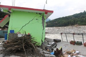
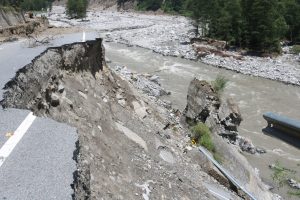
 Kullu valley is an ideal holiday destination for many Indians; a place that offers temperate weather, stunning landscapes, and the warmth of its hard working communities, all of which provide a welcome break from the everyday mundaneness of city life. At the same time, the escalating impacts of climate change in the region, especially in the form of flash floods, is becoming too apparent to ignore.
In 2018, heavy rains led to severe flooding in Himachal Pradesh, including in the Kullu valley, as the Beas and Parbati rivers overflowed, causing widespread devastation. The situation repeated in 2023, when flash floods and heavy rains in July and August resulted in the destruction of homes and properties, with the state government estimating losses of over Rs. 10,000 crores (Rs. 100 billion).
Understanding flood vulnerability
 In this context, a new study examines the flood vulnerability of Kullu valley by integrating both geoenvironmental and socioenvironmental analyses. The research used satellite imagery, Geographic Information System (GIS), and field surveys to assess the region’s topographical and hydrological attributes alongside land-use patterns, aiming to understand the extent of flood risk.
 The study notes that the concept of vulnerability has “evolved through interdisciplinary contributions” and cites the Intergovernmental Panel on Climate Change (IPCC) to define vulnerability as encompassing three primary dimensions: exposure, sensitivity, and adaptive capacity. “Exposure refers to the presence of environmental hazards, sensitivity denotes the susceptibility of a system to such hazards, and adaptive capacity represents the system’s ability to adapt and respond to potential impacts.”
The new study, led by Kesar Chand from the G.B. Pant National Institute of Himalayan Environment, was conducted in the Kullu valley within the Beas basin. The research team identified several critical geoenvironmental factors affecting the landscape’s vulnerability to flooding, including topography, slope, soil texture and type, surface runoff, channel gradient, and land use and land cover (LULC).
“The study area is a vertically extended valley with various types of land use, such as agriculture, horticulture, and tourism. It is a narrow valley where tributaries of the river Beas originate from high altitudes with slopes of 45-60 degrees. During heavy rainfall or cloudbursts, runoff and mud from eroded soil flow into the river Beas,” explains lead author Kesar Chand. The study highlights that “the complex interplay of steep slopes and intricate stream networks exacerbates the susceptibility to flash floods in the region.”These findings align with a hydrometeorological analysis of the 2023 floods in Kullu valley, by a team of researchers led by Vivek Gupta, a professor of Civil and Environmental Engineering Department at IIT Mandi. Gupta explains that the risk of extreme weather events like floods depends on two main factors: hazards and vulnerability.
In the case of the flood-affected region, Gupta’s study identifies three primary hazards: high precipitation, elevated soil moisture, and snow erosion due to rainfall. Vulnerability, however, is often influenced by socio-economic factors. “If a river overflows during a flood and there are houses and buildings in the vicinity, the area’s vulnerability naturally increases,” he notes.
Zonation of high-risk area
The socioenvironmental analysis in Chand’s study identified five distinct zones within the region, each with unique adaptive capacities, exposures, and sensitivities. Floodplain zonation studies are widely used globally to assess flood vulnerability. In this case, the study found Zones 5 and 4 to be highly vulnerable due to dense settlements and economic reliance on agriculture and tourism.
The GIS analysis indicated that approximately 22 square kilometres of varied land use within a 100-metre buffer from the main river (Zone 5) are at high risk of severe damage during flash floods. “We identified Zone 5 as particularly vulnerable to floods, emphasising the importance of restricting activities and interference in this area. This recommendation aims to minimise the impact of extreme weather events, such as those experienced during the 2018 and 2023 floods,” Chand explains.
The significant damage caused by previous floods is largely attributed to geoenvironmental factors such as high relative relief, steep slopes, dense stream networks, and adverse land-use changes. According to the paper, these indicators were crucial in shaping the dynamics of the 2018 flood, which experienced a high surface runoff of approximately 680 cubic metres per second over 24 hours, leading to severe socio-economic losses.
Need to regulate tourism
Chand identifies unregulated tourism as a major factor contributing to the region’s devastation during previous floods. He suggests that assessing the region’s carrying capacity and regulating tourism are key measures to mitigate the impact of extreme weather events.
“During peak tourist seasons, we see 5,000 to 6,000 tourist vehicles in the region each day. Many of the disasters here can be traced back to anthropogenic activities. While we cannot eliminate economic activities, we can certainly regulate them,” Chand states.
One of the purposes of the study, he says, is to raise awareness about the high vulnerability of certain areas through zonation. “We know that highly vulnerable areas are those closest to the river. Despite this, people continue to build hotels and establish businesses right next to the river, which exacerbates disaster losses,” he notes.
To address these issues, the study recommends establishing a 100-metre buffer zone along the river and monitoring the use of Common Property Resource (CPR) lands to mitigate flood risks. Additionally, it advocates for implementing sensible land-use policies to discourage settlement in high-risk areas.
The study also proposes several mitigation strategies, such as integrating traditional knowledge with environmental and technical expertise to develop adaptive strategies within communities.
Similarly, a more effective early warning system is another suggestion by experts, including Gupta. Gupta says that instead of focusing only on precipitation levels, an improved early warning system should account for factors that determine the potential water inflow to the river such as snowmelt and soil moisture, as demonstrated by the 2023 floods.
Other recommendations include strengthening communication infrastructure and enhancing the training and resources of disaster response teams. The study acknowledges its limitations due to the restricted area examined and recommends expanding future research to other flood-prone regions to develop a comprehensive regional flood mitigation policy. Chand indicates that the study has been shared with state disaster management authorities, and he hopes they will consider the findings and take action promptly.
Mongabay India/TWF
Photos and captions:
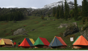
1. The Bhandak Thatch Camp in Himachal Pradesh during Sar Pass Trek in Kullu district of Himachal Pradesh. The Kullu valley region is vulnerable to floods due to many geological, social and environmental factors, as per a new study. Image by J.M. Garg via Wikimedia Commons (CC BY-SA 3.0).


