 After the 2004 tsunami, mangroves in the Andaman and Nicobar Islands are still changing. A mass mortality of mangroves was followed by a slower die-off over the decades. While mangroves can adapt well to changing tidal conditions over time, it is important to remove anthropogenic disturbances and invasive species or overgrazing, to support regeneration. Mongabay-India correspondent Divya Kilikar reports
 On December 26, 2004, the Andaman and Nicobar Islands changed forever. A tremor stirred 30 kilometres deep beneath the ocean floor in the Sunda trench off the coast of Sumatra, Indonesia. It reverberated into a deadly earthquake of 9.1 magnitude. Massive waves engulfed the entire archipelago. At least 250,000 people were severely affected. A tsunami, the result of this tremor, was witnessed across South and Southeast Asia, and even distant East Africa. Human and socio-economic losses were brutal. To this day, we are yet to understand the full impact of this tragic event on the Andaman archipelago.
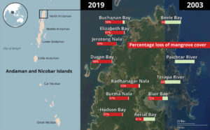
 The tsunami also impacted mangroves along the coast of the Islands. While initial reports recorded a 60-70 percent loss of mangrove cover, detailed studies reported a 97 percent loss. Twenty years after the devastation, the archipelago and its mangroves are still reeling from the aftermath.
A study published in May 2024 monitored the long-term response of mangroves to the geomorphological changes left in the wake of the tsunami. North Andaman experienced coastal uplift (sea level drop or SLD) of approximately 1.3 metres, while South Andaman experienced coastal subsidence (sea level rise or SLR) of about 1.1 metres. Little to no changes were observed in Middle Andaman.
 Mangrove species are changing slowly but surely in the 20 years since the tsunami. “The uplifted sites mimicking the SLD scenario appeared more destructive to mangroves (tree density – 771/ha) in comparison to subsided sites mimicking the SLR scenario (tree density – 937/ha),” noted the study.
The turning of the tide
It was the alteration of the tidal regime that led to the mortality of mangroves, as well as subsidence and upliftment of coastal areas. “Changes in the tidal regime can cause significant damage since mangroves occur in the intertidal zones,” explains Nehru Prabakaran, lead author of the study. He is a scientist with Wildlife Institute of India (WII), and has been studying the mangroves in the archipelago since 2009.
“Tidal amplitude (the difference between high and low tide) in the islands is about 1.5 to 2 metres. When there is a sudden one metre change, a new intertidal zone is created towards the ocean side in case of upliftment and towards land side in case of subsidence,” Prabakaran explains. Upliftment renders that part of the coast no longer ideal for coral reefs. Meanwhile, subsided sites become more colonised by seagrass. Areas that were once terrestrial turn intertidal – these included human habitations and paddy fields.
He also warns how this change may leave a significant impact. “There are 39 species of mangroves on the islands, each thriving in a different tidal course. Some species can survive in varying levels of tides, while others cannot. All these established patterns change when you have even a few centimetres of difference in the sea level. This also impacts the carbon stocks of the mangroves, as different species store different amounts of carbon,” he says.
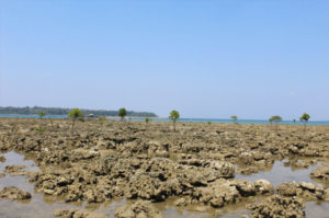
The researchers noted that in the flooded zones in uplifted sites, species suited for high flooding managed to survive for a period of time. Despite a significant reduction in the number of high tides that this vegetation would normally experience, conditions were just about suitable enough to help mangrove cover survive, but not reproduce. However, a gradual die-off of trees was observed, which were eventually replaced by different species that were suited for less flooding.
“When we looked at satellite images over the years, we saw that mangrove trees in the uplifted areas managed to survive after the 2004 disaster up until 2008, after which there was a tipping point when trees began to sharply decline. In maximum uplift areas, there was mass die off of trees which led to other species replacing them,” says Prabakaran.
The islands’ mangrove ecology steadily changes
Mangrove species that require more flooding are slowly colonising the uplifted sites – these are mainly of Rhizophora and Avicennia genera, according to the study. Subsided sites are seeing more terrestrial species such as Ceriops tagal, taking over.
Seedlings were recorded in the highest numbers in uplifted sites, followed by control and subsidised sites. As large, old growth mangroves that may have been as high as 25-30 metres died in masses at these sites, opportunities rose for seeds to take root. However, while seedlings may thrive momentarily in disturbed conditions, they die quickly due to unsuitable environmental conditions.
Surprisingly, the density of dead trees was noted to be the highest in areas that experienced little to no change. Prabakaran suggests that while the disturbed sites experienced an instant mass mortality following the tsunami, control sites witnessed a slower death of trees. This points to the inevitability of mangrove cover degrading or dying across the archipelago.
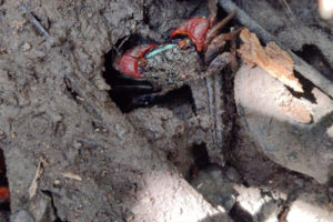
Around 70-80 species of crabs that depend on the mangroves are affected as well, according to Prabakaran. “Some are only restricted to the soil layer or root layer. Some climb up to feed on fresh leaves. Some prefer particular species of mangroves. Therefore, when mangroves change, so do crab communities,” he says. He adds that chital, which is an invasive species in the archipelago, are further degrading the ecosystem by overgrazing. Their ability to survive on saltwater, swim across islands and feed on all vegetation poses a critical threat to the understory and regeneration capacity of the mangroves. According to Prabakaran, the main threats now are anthropogenic and invasives.
Vulnerability to future disasters
Another study published in March 2024, found that about 34% of coastal areas and 23% of mangroves across all zones in the islands are highly to extremely highly vulnerable to disasters and other effects of climate change.
“Subsided zones were found to be more vulnerable than uplifted zones. These findings suggest that large-scale natural disturbances such as tectonic displacement have the potential to impact coastal vegetation and mangrove cover can become even more vulnerable,” the study stated. Its findings emphasise the importance of understanding the vulnerability of coastlines, especially regions likely to experience seismic activity.
The study analysed vulnerability in the form of six parameters – geomorphology, rate of shoreline change, sea level rise, regional elevation, coastal slope, bathymetry (measurement of depth of water in a water body), mean tidal range, and mangrove area coverage. It also identified vulnerable areas that require conservation planning.
Kathiresan, honorary professor at Annamalai University who has been studying mangroves in Pichavaram, Tamil Nadu, for decades, believes that mangroves have a capacity to regenerate like no other. “The mangroves prefer to colonise intertidal areas. Over the course of time, mangroves can adapt well to changing tidal conditions, even the affected mangroves of Andaman. Those in the peripheral intertidal zones at uplifted sites can trap sediment and build land back over time. Some mangrove species like Rhizophora apiculata and Ceriops tagal have high resilience for sudden changes in tidal regime. In submerged areas, flood-tolerant species like Aegiceras corniculatum and Avicennia marina can colonise,” he says.
The Centre for International Forestry Research and World Agroforestry (CIFOR-ICRAF) is working to understand the resilience of mangroves, especially to SLR. “India is witnessing SLR of 4.5 millimetres per year, which is higher than the global average of 3.4,” says Samakshi Tiwari, a research fellow at CIFOR-ICRAF. “We’re conducting long-term monitoring at several mangrove sites across India to understand sediment dynamics using rod surface elevation tables (rSETs). We have established 17 monitoring sites in the Andamans, 20 in the Sundarbans and 10 in Coringa, and will soon have data from them.
“Mangroves have historically been able to keep up with the conventional SLR scenarios due to sediment deposition and root biomass expansion to be able to maintain the inundation regime in coastal ecosystems,” says Rupesh Bhomia, a senior scientist at CIFOR-ICRAF. “This ability underpins their long-term sustainability.”
Kathiresan also emphasises that community conservation efforts must be maximised for long-term conservation and regeneration of mangroves. His work in Pichavaram is an example—here, community members are involved in planting mangroves and maintaining nurseries, and fisherfolk are free to fish in legally protected mangroves. Following such efforts, one study noted that mangrove cover here had increased by 90%.
He further suggests that permeable structures like bamboo fencing installed around the mangroves can facilitate sedimentation, which helps in natural colonisation of mangrove seedlings, as proved in Indonesia.
Prabakaran adds that mangroves have an incredible capacity to regenerate naturally and the only intervention needed from humans is to remove disturbances (anthropogenic and invasive species/overgrazing). “If conservationists choose to take up planting to support regeneration, mangrove species should be chosen based on the new characteristics of the subsided and uplifted sites. But planting is not a necessity.”
Mongabay India/TWF
1. The large-scale mortality of mangroves in the Nicobar Islands still reminds us of the wrath of the tsunami and land subsidence impacts. Image by Nehru Prabakaran.
3. Mangrove colonisation at the uplifted reef beds across the west coast of North Andaman provides optimism for ecosystem resilience and recovery. Image by Nehru Prabakaran.
4. These crabs with their unique adaptation to the mangrove ecosystem were among the worst impacted by the large-scale mangrove degradation due to tsunami, subsidence and uplift. Image by Nehru Prabakaran.
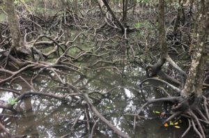
5. Mangroves in Andaman’s Baratang island. Image by Saveribn/Wikimedia Commons (CC BY-SA 4.0)


