By Glenn C. Kharkongor and Brian D. Kharpran Daly
An IUGS Geological Heritage Site is a key place with geological elements and processes of international scientific relevance, with a substantial contribution to the development of geological sciences through history. These sites can be considered natural laboratories to record geoscientific knowledge on natural phenomena and geodynamic processes in order to benefit properly from their sources and avoid disasters. These geoparks are enhancing innovative methodologies for preserving the geological heritage and supporting the development of scientific research in the various disciplines of Earth Sciences. Geoparks promote the links between geological heritage and all other aspects of the area’s natural and cultural heritage, clearly demonstrating that geodiversity is the foundation of modern ecosystems and the basis of human interaction with the landscape.
UNESCO Global Geoparks encourage awareness of the story of the planet as read in the rocks and landscape and are committed to the conservation, management, and communication to society of the Earth heritage as an integral part of the world’s natural and cultural heritage.
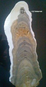
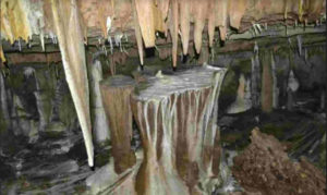
Mawmluh, about 60 km from Shillong, is a village near Sohra (Cherrapunjee) located at N 25°15’32” E 091°42’43”, at an altitude of 1160m. The cave, known locally as Krem Mawmluh, is 7.194 km long. The stalagmite from which the calculations for the Meghalayan Age were obtained, was taken from the Hanging Gardens, a large hall in the cave, about 1.5 km from the entrance of the cave. The stalagmite is about three feet long and is about 40,000 years old, showing rainfall patterns for the last 40 millennia.
In the listing, Mawmluh Cave is number 23 and the chapter carries the title, “The GSSP of the Youngest Unit of the Geologic Time Scale Associated with Dramatic Climate Changes with Implications on Human Civilization”. It is listed in the section on Stratigraphy and Sedimentology. The formal announcement was made at the IUGS (International Union of Geological Sciences) 60th Anniversary Event in Spain on Oct 25, 2022. This listing is supported by UNESCO.
Global Boundary Stratotype Sections and Points (GSSPs) are reference points that define the boundaries of stages on the geologic timescale. It may contain fossils and minerals that can be dated. They should be accessible to research and free to access, kept in good condition (ideally a national reserve), in accessible terrain, extensive enough to allow repeated sampling, and open to researchers of all nationalities. Stratigraphy refers to the layers of the Earth’s crust and sedimentology to sedimentary rock in which fossils, other biostructures, and minerals may be present.
The full IUGS text
 The site is the GSSP for the Meghalayan Stage of the Holocene Series. The stalagmite sample of Mawmluh cave has shown that they were not subjected to diagenesis and erosion and that they are suitable for preserving chemical signatures. The stalagmite has preserved a very high-resolution record of Holocene paleo-climate and paleo-monsoon. Intensive Oxygen Isotope analyses revealed that around 4,200 YBP (Years Before Present), there was a mega-drought event that devastated many civilizations. The more intense period of weakened monsoon occurred from 4071 to 3888 YBP and marked as nearly a global event.
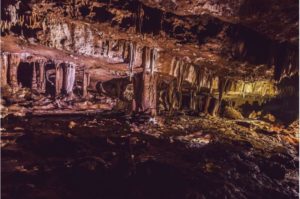
The Mawmluh Cave, known locally as Krem Mawmluh, is formed along the contact between the Early Eocene Lakadong dolomite of Sylhet Limestone Formation and the Therria Sandstone Formation. At present, the cave is a 7.2 km long maze with many openings and decorated with stalactites, stalagmites, columns, drapes, and moon milk.
The Meghalayan Stage is the newest entrant in the geologic history of the Earth and the latest of three subdivisions of the Holocene Epoch. The International Commission on Stratigraphy officially ratified it along with the earlier Greenlandian and Northgrippian Stages. The lower boundary of the Meghalayan Stage is defined at a specific level in a stalagmite sourced from Mawmluh Cave. The uranium series dated Upper Pleistocene to Upper Holocene stable isotope profile shows a marked shift to heavier isotopic values at ~4.2 ka (4200 years), reflecting an abrupt reduction in precipitation due to a weakening of the monsoon across the 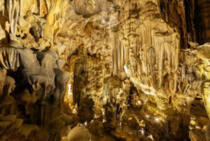 Indian subcontinent and southeast Asia. Due to the abrupt mega-drought, the agriculture-based society nearly collapsed.
The 4.2 ka event was global or near-global in nature and constitutes a time-stratigraphic marker. The speleothems of Mawmluh Cave, Meghalaya have been extensively studied by many researchers. The Working Group of The Sub-commission on Quaternary Stratigraphy (SQS) of the International Commission on Stratigraphy (ICS) proposed the subdivision of the Holocene Series and later IUGS formally ratified and accepted the three-fold classification with the youngest Stage ‘Meghalayan’ in the year 2018.
Categories of the 100 IUGS Sites
|
Category |
Description |
Sites |
Countries |
|
History of geosciences |
A place where a specific feature grew new ideas and theories which changed the understanding of the geological history of the Earth. |
11 |
Canada, UK, Portugal, Spain, Sweden, France, Italy, Czech, Japan |
|
Stratigraphy and sedimentology |
Stratigraphy studies rock layers to compute the age of formations. It uses fossils, chemicals, and minerals for correlation. These sites document a unique event in the history of our planet. |
12 |
USA, Spain, Portugal, Italy, Nepal, India, China, South Africa, Namibia, Brazil, Antarctica, |
|
Palaeontology |
Fossils can be the remains of animals or plants, fungi or bacteria, with sizes ranging from nanometres to metres, preserved in the sedimentary rock record. |
19 |
Australia, China, Mozambique, Tanzania, Uganda, France, Greece, Poland, Germany, Morocco, Portugal, Jamaica, Canada, Colombia, USA |
|
Igneous and metamorphic petrology |
Igneous petrology studies rocks that form by crystallisation from magmas (lava), and volcanic rocks. Metamorphic petrology is the study of rocks that form through transformations that occur deep in the Earth. |
8 |
Malaysia, China, Australia, Mauritania, Canada, USA, Chile |
|
Volcanology |
Volcanoes provide an essential exchange of materials from the interior of the Earth to the surface and atmosphere, providing environments for the biosphere. They are a resource, a cultural influence, and at times a hazard. |
17 |
Vanuatu, Tanzania, Eritrea, Tanzania, Saudi Arabia, Turkey, Greece, Germany, Cameroon, Chile, Ecuador, Colombia, Costa Rica, Peru, Nicaragua, Samoa, USA |
|
Tectonics |
Tectonics is the evolution of the lithosphere and the forces that cause its deformation. Plate tectonics allows us to study mountain building, earthquakes, and their effect on the Earth’s surface through time. |
7 |
Japan, China, Iran, UK, France, USA |
|
Mineralogy |
Mineralogy refers to the study of minerals that formed on Earth or delivered from other planets as meteorites. About 6000 minerals are known. |
3 |
Namibia, Spain, Uruguay |
|
Geomorphology and active geological processes |
Geomorphology is the study of landforms and their evolution as a result of Earth surface processes. Biogenic activity, as well as human action, may also play an important role in shaping landforms. |
22 |
China, Australia, Iran, Madagascar, Botswana, Zambia, Zimbabwe, Turkey, Slovenia, Norway, Switzerland, Italy, Namibia, Brazil, Cuba, Argentina, Mexico, El Salvador, Chile, USA |
|
Impact structures and extraterrestrial rocks |
Meteorite impacts record the history of collisions between celestial bodies during the evolution of the solar system. Our Earth has suffered multiple impacts from asteroids and comets. |
1 |
 Meghalaya has examples of many of the features of the IUGS categories. The Shillong Plateau is rich in fossils. The caves have seams of fossil deposits called coquina. Lum Diengiei, the location of the Khasi folktale of the big tree, seems to have a volcanic crater at the summit. Exposed tectonic plates can be seen at the Dawki Fault, on the southern cliff slopes of the state border with Bangladesh. Mineral ores, such as iron and uranium are in abundance.
The government should declare June 26 every year as Meghalayan Age Day. The state should declare the Mawmluh cave system and the surrounding buffer area as a state geopark. An NGO with cave and conservation expertise, along with the local community should be 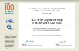 entrusted with the care of the cave. While access to parts of the cave could be accessible to tourists, other sections may be reserved for scientific research.
The plea for the protection and conservation of Krem Mawmluh as well as Siju Dobhakol was brought to the notice of the state government as long back as 1997, followed up by intermittent reminders. The cave system silently bore the onslaught of limestone mining for more than sixty years and its collapse was not too far away. Then the heavens answered – Krem Mawmluh presented the state with a slice of Earth’s history, followed by this recognition of UNESCO. The onus now is on each one of us to protect and conserve this invaluable scientific resource for the betterment of mankind and for our future generations.
Sources
-
The First 100 IUGS Geological Heritage Sites, 2022. International Union of Geological Sciences
-
Global Boundary Stratotype Section and Points. International Commission on Stratigraphy.


